
Cell Coverage Maps Come To Offline Navigation Tools
Easily see where your phone will get signal, even when you have no signal

Thanks to an expansion in publicly available data from the Federal Communications Commission, accurate, easy-to-use information showing where and how much cell signal is available in what places is now available on your favorite mapping app. Let’s explore how you can take advantage of it, and the new possibilities it creates.
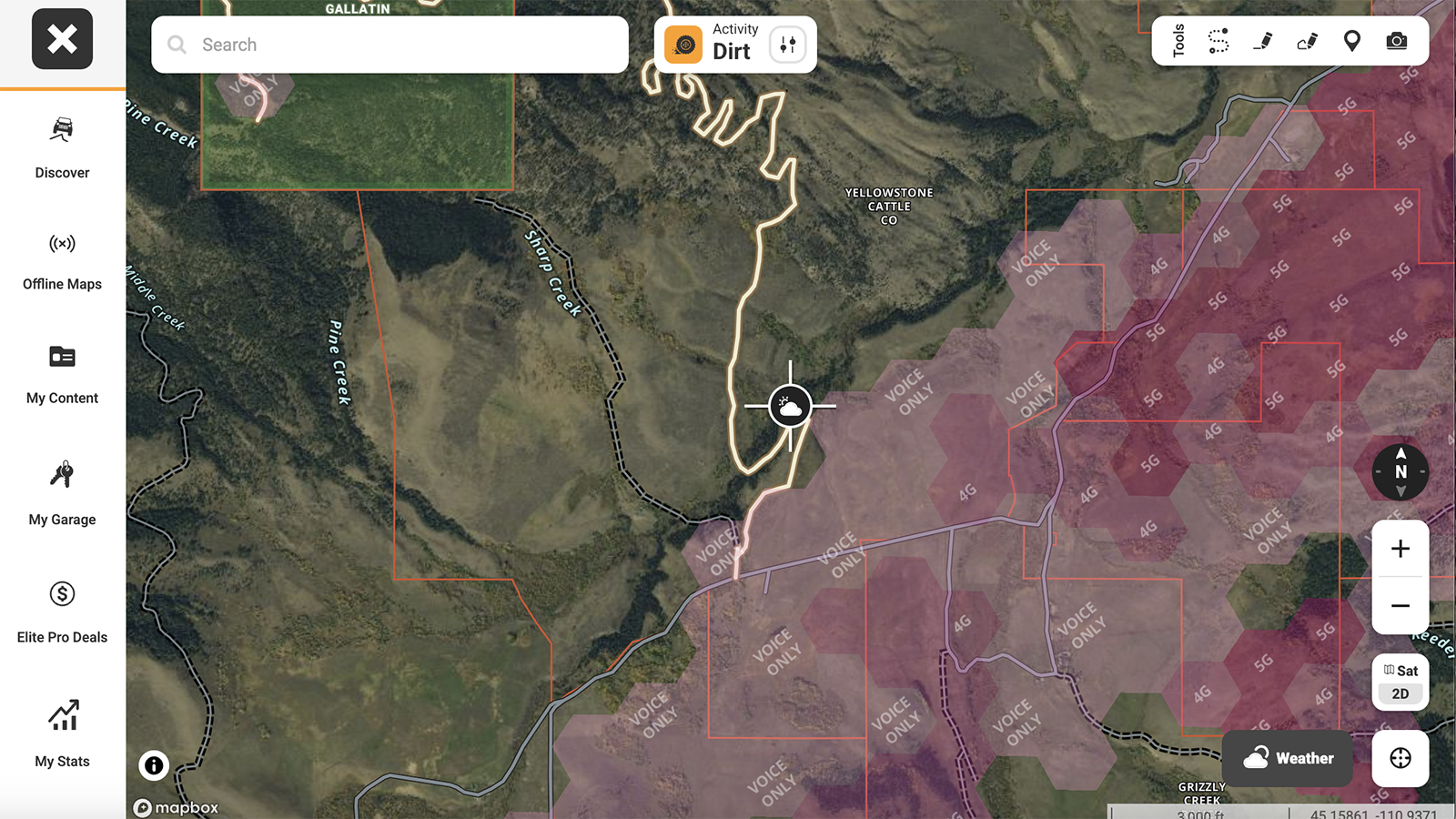
Above: OnX parses available coverage by data speeds and cell networks (Verizon, AT&T, or T-Mobile).
Like it or not, but digital connectivity is quickly expanding into the backcountry. SpaceX’s Starlink satellite internet network has expanded high speed coverage to nearly the entire globe. But its expensive equipment (plus the additional systems necessary for powering it) is still too bulky for most human-powered adventures. T-Mobile is currently working with Starlink to expand a limited version of that connectivity to smartphones. But satellite-to-phone data speeds won’t exactly be fast anytime soon, so that functionality may be limited to text messaging and SOS only for the foreseeable future. The same is true for satellite messenger gadgets made by companies like Garmin.
All of those services require special equipment, dedicated data plans, or both. Sometimes you just need to make a phone call, send a text, or check in with the real world without a bunch of planning or hauling a ton of crap around. And it’s in those instances where I think knowing exactly where to find cell coverage will be incredibly useful.
I learned about this functionality last week, when OnX announced its arrival on their Offroad app. But a quick search showed that it’s also available on OnX Hunt and has been on CalTopo (a free tool) since 2022. Gaia added it for premium members last July. The FCC actually began providing the information in 2021, so I guess what’s new here is that I learned about it, and it’s now widely available on common navigation apps.
I reached out to my friends at OnX to ask how it works.
“The FCC requires any mobile service provider to provide detailed coverage maps to the FCC, which it redistributes as the National Broadband Map,” explains Chris Cordes, who runs content for OnX Offroad. “The FCC requires mobile voice + broadband providers to submit coverage maps twice per year, and they release those maps with the same cadence which is when we update our own.”
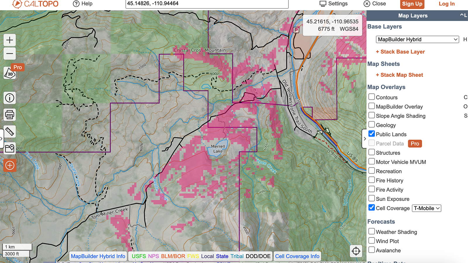
CalTopo offers basic map building functionality for free, including FCC data around the availability of Verizon, AT&T, or T-Mobile coverage. Areas included provide “4G LTE broadband service at a minimum user download speed of 5 megabits per second and a user upload speed of 1 megabit per second.”
So map providers are taking this basic data set from the FCC, and making it easy to add as a layer on top of the navigation apps you’re already using. All you really need to take advantage of it is the awareness that it’s available.
Why am I excited about this? It adds certainty to a situation I’ve tried to figure out through guesswork multiple times.
Last fall, I wanted to invite my friend Will to come join me at my hunting camp. I had a hunch I might be able to find some signal on top of a mountain peak, but wasn’t sure it was there until I hiked all the way up, and was able to text him. I wanted to use my phone to text him because messaging over my Garmin involves lengthy delays, and you can’t always guarantee you’ll receive replies sent by the phone users on the other end. Using cell service meant we could go back and forth on location, route of travel, and eta in just a few minutes.
It’s easy to spitball that example into stuff both serious and mundane. What if you’re not carrying a Garmin or similar? What if you need help with something that won’t or hasn’t yet risen to the level of a real, life-threatening emergency? What if you just want to pick up the phone and call your partner to say hi? What if one of your colleagues needs incredibly pedantic instructions about how to perform their own job, and that information can only be delivered with a voice call? This mapping feature will allow to find the places where you can do all that, without just climbing a freakin’ mountain on a hunch.
The ability to stay connected allows me to spend more time recreating outdoors, more often.
For some background, since not everyone reading this will remember a time before cell phones were universally available, cell phone signal does not just float around in the air universally. Your phone communicates with physical cell towers via two-way radio transmissions. Not only is the outright power of those radio transmissions limited by the size and battery capacity of your device, but it’s also carefully regulated by the FCC to prevent cell towers from interfering with other types of communications and equipment. In a best case scenario, your phone is able to connect to a cell tower that’s up to 22 miles away. But the frequencies used here are also line-of-sight, so terrain like hills and mountains can interfere or block it entirely, as can the water contained in foliage or the atmosphere. So that 22-mile distance can quickly decrease.
The tiles on these maps show areas that have line-of-sight visibility with a cell tower that’s less than 22 miles away. It’s worth noting that fog, air temperature, inversions, and other atmospheric conditions could limit or impair the strength of that signal, and that towers can experience damage or be temporarily taken offline for maintenance. I explored variables in cell signal strength in this Outside article, way back in 2017.
How do you use the cell coverage layers in these apps? If you’re using OnX, just download an area for offline use, and data for the available layers will saved to your phone, so you can just toggle it on when you need it. Other apps or systems may require you to build that offline map with your desired layer data already displayed. OnX also parses availability by data speed, should you need to do a video call or manage larger files.
Anyways, this is an additional connectivity capability I’m excited to start using outdoors, so figured you guys would want to know about it too.
Wes Siler is your guide to leading a more exciting life outdoors. Upgrading to a paid subscription supports independent journalism and gives you personal access to his expertise and network, which he’ll use to help you plan trips, purchase gear, and solve problems. You can read more about what he’s doing on Substack through this link.
The biggest issue is Starlink…like Tesla, not a fan.
Is there a reliable device that will detect falls and alert contacts in the wilderness? Apple Watches aren’t reliable re fall detection. I had a serious mountain bike crash last June and my watch didn’t send an alert. It does, however, activate the call alert every time I fluff pillows on my sofa.