


Cascadia Earthquake Flooding Risk Two To Three Times Worse Than Current Predictions
Quake subduction could combine with sea level rise to dramatically expand tsunami zone


New research published by the National Academy of Sciences this week finds that a major earthquake off the shore of the Pacific Northwest could cause coastal land to immediately sink up to seven feet. Paired with sea level rise, this could expand flooding risk due to the subsequent tsunami to an area 150 square miles larger than previously thought.
“We could have a disaster on the scale of Japan 2011 or Sumatra 2004,” the study’s lead author told The Washington Post. “It’s the same kind of fault. It has the same capability of making a huge earthquake, tsunami and coastal subsidence.”
Fellow preppers and disaster enthusiasts may recall the 2015 New Yorker article on the threat posed by an earthquake in Cascadia Subduction Zone, and the extreme reactions it kicked off across the Internet.
“Thirteen thousand people will die in the Cascadia earthquake and tsunami,” that article began. “Everything west of Interstate 5 will be toast.”
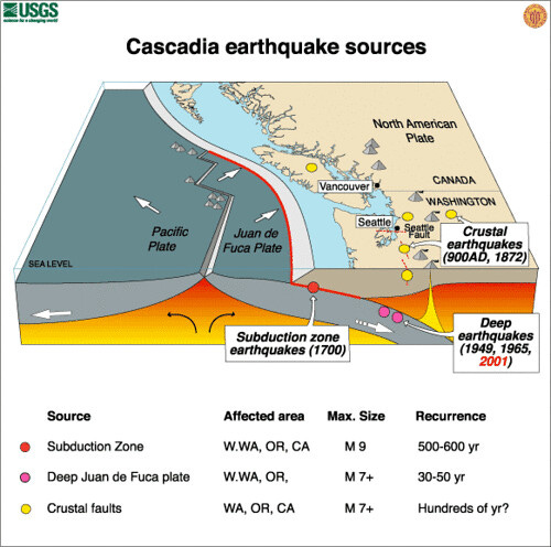
To recap, a fault line off the coast of northern California, Oregon, and Washington, running north to British Columbia, is made up of an offshore tectonic plate slowly sliding under the North American plate. As the Juan de Fuca plate pushes onshore, pressure builds over centuries, until it suddenly releases, causing an earthquake. The offshore location and type of fault are just right for generating major earthquakes and massive tsunamis.
By reviewing soil deposits, tree rings, and studying the fault itself, scientists have established that the fault produces a major event once every 450 to 500 years. The last one occurred in 1700, 324 years ago.
“It could happen any day, but it might not happen till 2100,” this new study’s author explained to The Washington Post.
A tsunami caused by a quake on the Cascadia Subduction Zone could reach a height of 40 feet.
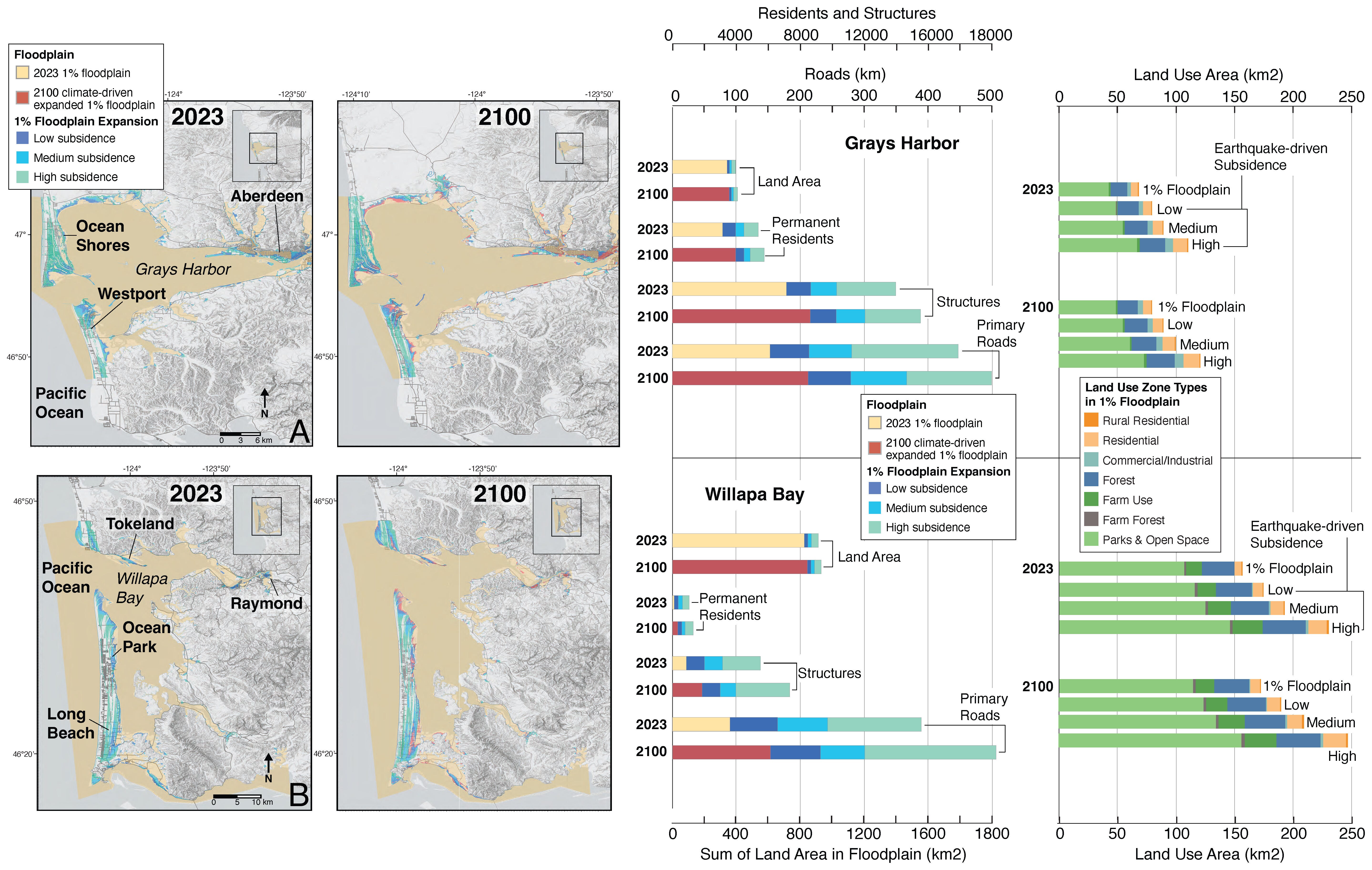
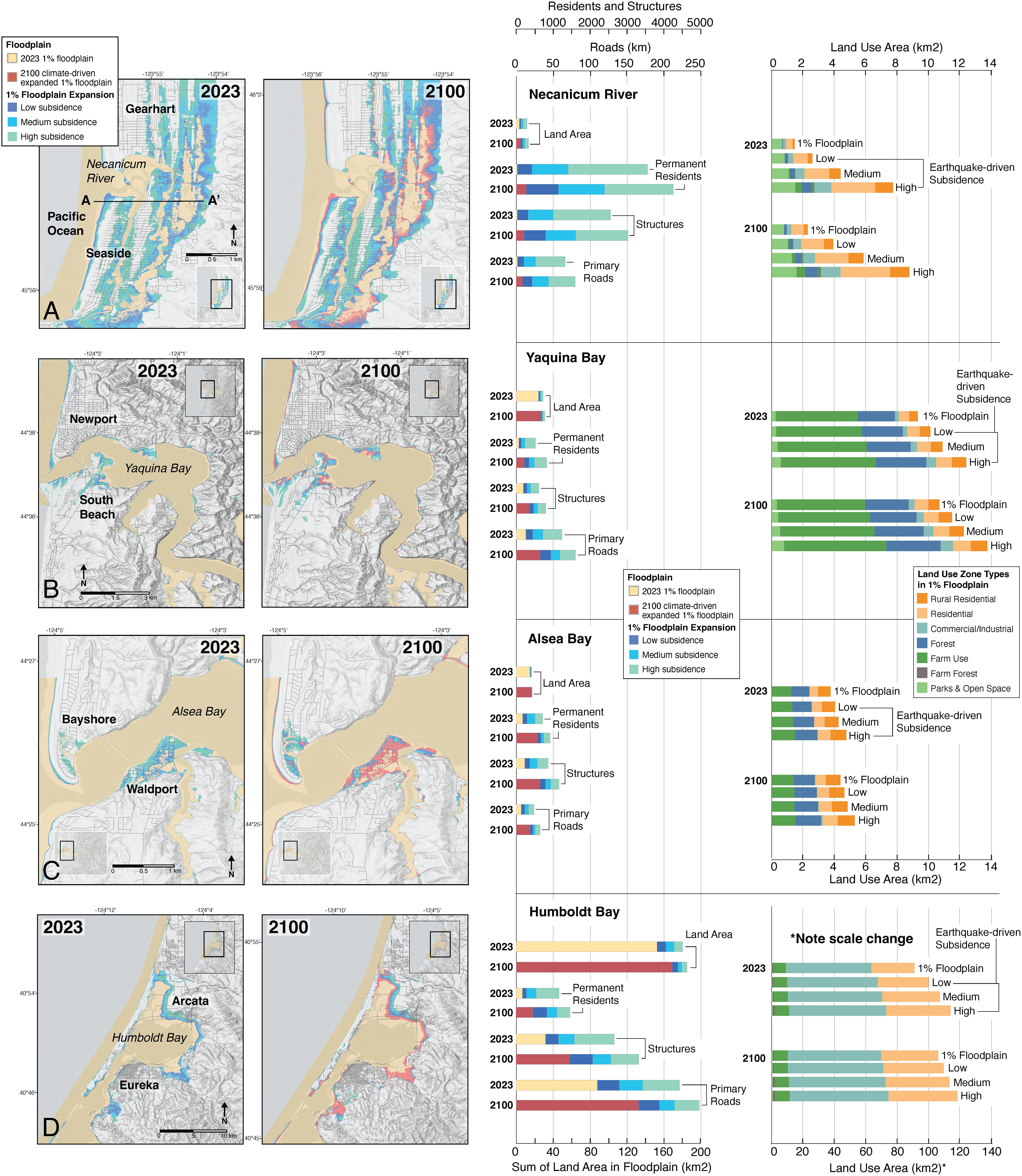
This new report finds that the risk of subsidence is worse than previously feared—up to 6.5 feet. And, depending on when the next quake occurs, that could combine with sea level rise to dramatically expand the degree of coastal flooding.
“By 2100, earthquake subsidence amplified by projected climate-driven sea-level rise could more than triple the flood exposure of residents, structures, and roads,” reads the report. “This study underscores the need to consider combined earthquake and climate impacts in planning for coastal resilience at the Cascadia Subduction Zone and globally.”
The report says the compounding risk of sea level rise in the PNW is currently underestimated. While the global average rate is around 4.5mm/year, the subduction is currently working to push the region’s coast upwards by 1 to 3mm/year, reducing current flood risk.
But, “…by ~2030, rates of climate-driven sea-level rise are expected to outpace gradual uplift,” the report finds. “By 2050, central (50th percentile) sea-level projections for a high emissions scenario show 0.1 to 0.3m of [sea level rise]. By 2100, sea levels are projected to rise 0.4 to 0.9m.”
Those estimates are well below a worst case scenario. MIT estimates that the maximum predicted sea level rise at current emissions levels is up to 2.0 meters, or six-and-a-half feet.
The conclusion of the report is basically that quake-caused subduction + sea level rise = a much greater area at risk from a 40-foot tsunami, no matter where those numbers actually land. That additional risk could expose as much as 150 square miles of currently dry land to tsunami risk in the event of a major quake.
To illustrate what that might look like for coastal communities in the PNW, the researchers mapped current high risk flood areas (referred to here as “1% floodplain”), then added in the risk of subsidence and up to three feet of climate-caused sea level rise.
The result? Up to 17,710 additional permanent residents (2023 population levels) may find themselves exposed to tsunami risk. 29,060 additional structures are also exposed to that risk. That “thirteen thousand people will die,” claim that directed so much ire at The New Yorker a decade ago could be low.
Also way back when, I wrote a piece about the risk, combined with real world survival advice drawn from a similar even that occurred in Chile in 1960. The conclusion basically amounted to: Don’t live in the potential flood zone. And, if you do happen to find yourself there when the earthquake occurs, flee away from it, to high ground immediately. The takeaway from this new research should be that the zone at risk from tsunami flooding could be substantially larger than first thought, extending the area where you don’t want to find yourself post-quake further inland, and to higher elevations.
Reading my old piece, I’m also struck by its final conclusion: “There is no way FEMA or the military will be able to provide immediate aid to that many people, across such a devastated area. Survivors will need to rely on each other for that aid, perhaps for up to a month or longer.”
As with everything these days, the Trump administration could be making this now-worse prognosis even more devastating. The current President has not approved a single request for federal disaster relief so far in this term, even those issued by former members of his White House leading red states. Serial dog murderer Kristi Noem, who has somehow found herself in charge of Homeland Security, has also stated the administration’s intent to dismantle the Federal Emergency Management Agency in its entirety.
Wes Siler is your guide to leading a more exciting life outdoors. Upgrading to a paid subscription supports independent journalism and gives you personal access to his expertise and network, which he’ll use to help you plan trips, purchase gear, and solve problems. You can read more about what he’s doing on Substack through this link.
Hey Wes! I wrote about this earthquake & tsunami possibility a few years back and how it might effect the Willamette Valley and Portland if the Columbia River backed up and the quake was strong enough but my info was old and this is really interesting new data you're providing. My town would be in deep trouble but all the coastal communities from Astoria down to Newport would be obliterated.
Thanks Wes I didn’t have enough to worry about (Trump, my SS, losing my federal medical care or being picked up by ICE)now I gotta worry about prepping for an earthquake tsunami probability WTF😵💫